The 1964 Great Alaska Earthquake & Tsunami
THE EARTHQUAKE
At 5:36 PM Alaska Standard Time on Good Friday March 27, 1964, rupture began near the north shore of Alaska’s Cook Inlet, 36 miles WSW of Valdez and 88 miles ESE of Anchorage. It would take four minutes for the rupture to propagate, eventually rupturing a 500 mile by 125 mile fault area uplifting some areas by as much 30 feet and dropping down others by nearly 8 feet.
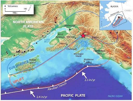
This map shows the epicenter (red star) of the earthquake and the approximate area of fault rupture. Uplifted areas are shown in red, and areas of subsidence shown in blue (Graphic provided by US Geological Survey.)
Ground Shaking
The earthquake was felt throughout most of mainland Alaska and from Ketchikan in the Southeast to the eastern Aleutian Islands, an area of over 800,000 square miles. If centered in Humboldt County, It would have been felt from Los Angeles to Seattle and inland to Utah and Idaho.
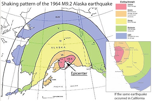
This maps shows the USGS felt pattern (isoseismal map) of the 1964 Alaska earthquake. Most of Alaska’s population at the time were in the area of violent shaking. The map in the lower right superimposes the 1964 earthquake shaking on California using the same scale and assuming the epicenter were in Humboldt Bay. It would have been felt as far away as Los Angeles.
Experience what it was like in Anchorage during the earthquake: Bob Pate worked for radio station KHAR in Anchorage and recorded what happened in his home.
More than 100,000 people in the greater Anchorage and other southern Alaska towns and villages experienced violent ground shaking. But only nine deaths were attributed to ground shaking effects. Many homes, like those of Bob Pate’s, experienced little structural damage. The low casualty rate was in part due to the time of day when most businesses and schools were closed and the wood frame construction typical of most structures in the area.
Liquefaction and Landslides
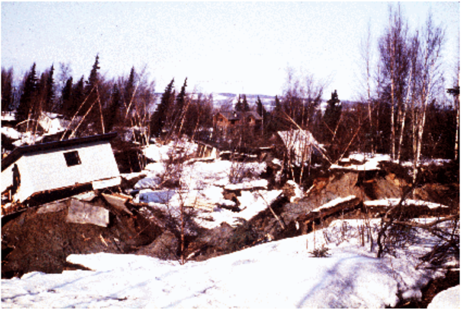
Much of the shaking damage was caused by landslides exacerbated by liquefaction. The friction during shaking melted the frozen ground triggering numerous failures in the greater Anchorage area. The most damaging was in Turnagain Heights where 130 acres of land slid as much as 2000 feet during the shaking, taking 75 homes and four lives with it. Other failures in downtown anchorage claimed businesses and a school.
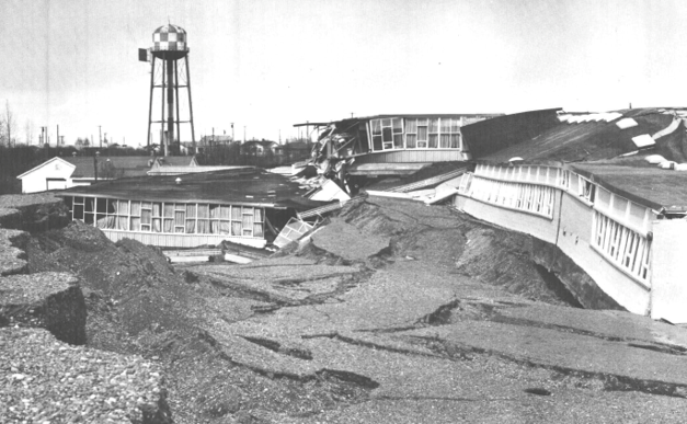
Government Hill Elementary School broke into several pieces; no one was in the school at the time.
Turnagain Heights landslide, USGS photo.
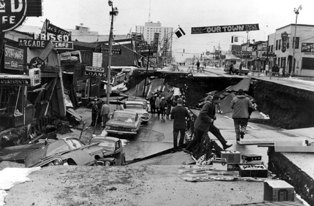
Liquefaction slumping in downtown Anchorage, USGS photo.
Fault rupture land level changes
The earthquake ruptured the subduction zone interface (megathrust) between the Pacific and North American plates. It also caused slip on a number of smaller upper plate faults related to the subduction zone. Plate tectonic theory was in its infancy when the earthquake struck and subduction zones had yet to be recognized. USGS geologist George Plafker carefully mapped surface faulting and how the land surface changed after the earthquake. The only interpretation of his data that made physical sense was slip along a gently dipping thrust fault.
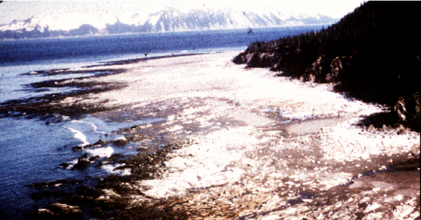
Uplifted seafloor on Montague Island where the highest uplift (33 feet) was measured (USGS photo).
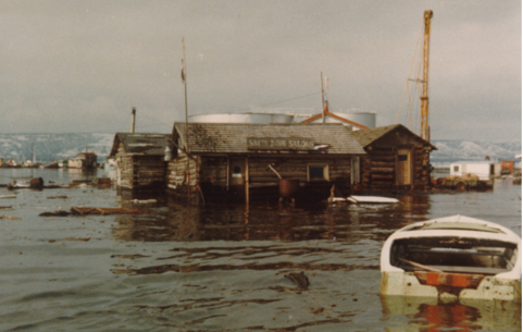
The town of Homer was in the area of subsidence. This is the Homer spit where 5.6 feet of downdropping was measured (Pratt Museum photo)
For more scientific background on the earthquake, visit the link below.
THE TSUNAMI WARNING SYSTEM IN 1964
The Honolulu Observatory was established as the U.S. Tsunami Warning Center in 1949, in response to the 1946 earthquake centered in Alaska’s Aleutian Islands that killed 159 people in Hawaii. The only real time instrumentation on site was a seismograph. The observatory was staffed during regular weekday work hours; in the evenings and weekends an alarm on the seismograph would alert duty personnel to return to the site. If the seismic record suggested a significant Pacific basin earthquake, staff would teletype requests to other observatories throughout the Pacific to telephone or teletype their seismic data to Honolulu. After the data was received, an epicenter was determined and information sent to civil defense offices of states which might be affected.
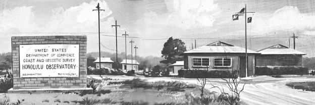
Honolulu Observatory in 1965 (NOAA illustration)
In 1964, the Alaska earthquake knocked out all communications within Alaska and between Alaska and other states. The only warning Alaskans received of a potential tsunami was the long duration of shaking. The Alaska Observatory did send alerts to Hawaii and West Coast states. The table below shows the timeline of actions taken by the Observatory. It took one hour and 16 minutes to estimate that the earthquake was centered near Seward, Alaska.
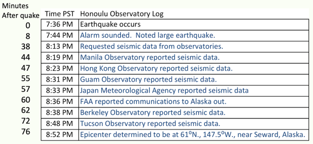
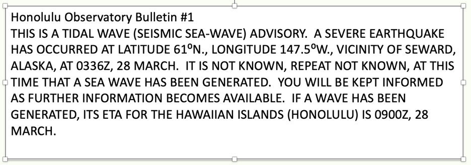
The first alert bulletin was issued at 9:02 PM PST. The term “tsunami” was not in use at the time and surges following earthquakes were called tidal waves or seismic sea-waves.
THE 1964 TSUNAMI
The earthquake was followed by tsunami surges that were recorded as far away as Antarctica and New Zealand. The tsunami caused more damage and casualties than the earthquake shaking. 106 people died in Alaska, 13 in California, and 5 in Oregon.
This numerical model shows propagation across the Pacific.
The Tsunami in Alaska
The tsunami in Alaska was complex, caused by both the seafloor deformation associated with the M9.2 earthquake and secondary landslides. In Valdez, the shaking triggered a large submarine landslide that arrived only minutes after the earthquake. Outside of the Prince William Sound area, first surges arrived in 20 to 50 minutes.
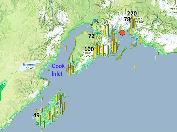
Compilation of measured peak tsunami water heights in 1964. Red circle is the epicenter, yellow bars are the relative water heights, numbers show select amplitudes in feet. Data from NOAA’s National Center for Environmental Information.
The Tsunami in California
In 1964, tsunami alerts messages were sent to State Civil Defense offices and not sent directly to counties. California’s Civil Defense Office received information from the Honolulu Observatory at 9:30 PM PST on March 27, but did not issue alerts to counties until 11:08 PM. By that time, the estimated time of arrival of the tsunami in Crescent City was midnight and Del Norte Sheriff’s deputies had less than an hour to evacuate coastal areas.
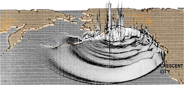
Numerical model of the tsunami about three hours after the earthquake, roughly the time Del Norte County officials were notified a tsunami could arrive around midnight. Vertical scale greatly exaggerated.
What happened in Crescent City?
A tide gauge on the Lumber Dock at Crescent Harbor had been installed in 1933 and was operating on March 27. Here are a series of time shots of the tide gauge record.
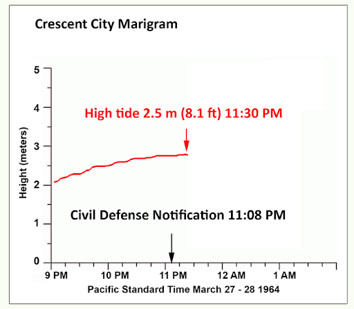
The tide gauge record at about the time of the Civil Defense notification. It was a clear night, a full moon, and high tide. The vertical axis is water height in meters relative to Mean Lower Low Water, the standard reference for tidal heights.
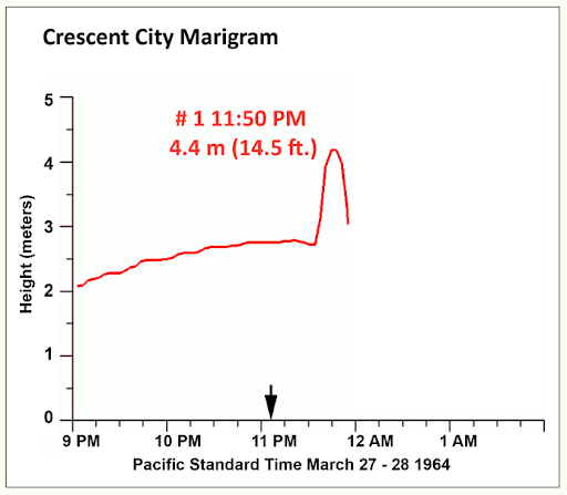
Tide gauge recording just after midnight. The first surge peaked at 11:50 PM on March 27th, with an amplitude about 6.4 feet above the tide, for a total of 14.5 feet. It caused flooding in the dock area and up to Front Street.
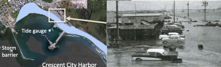
Blue area is an estimate of the inundation caused by the first tsunami surge in 1964. Eye witnesses described the flooding as very similar to what happened in May 1960 when a tsunami from the Chile magnitude 9.5 earthquake caused minor damage. Photo on the right shows 1960 water levels in the harbor area.
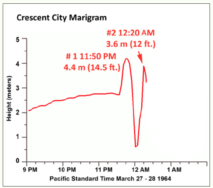
A second surge arrives 30 minutes after the first. It is smaller than the first but still causes some flooding in the waterfront area.
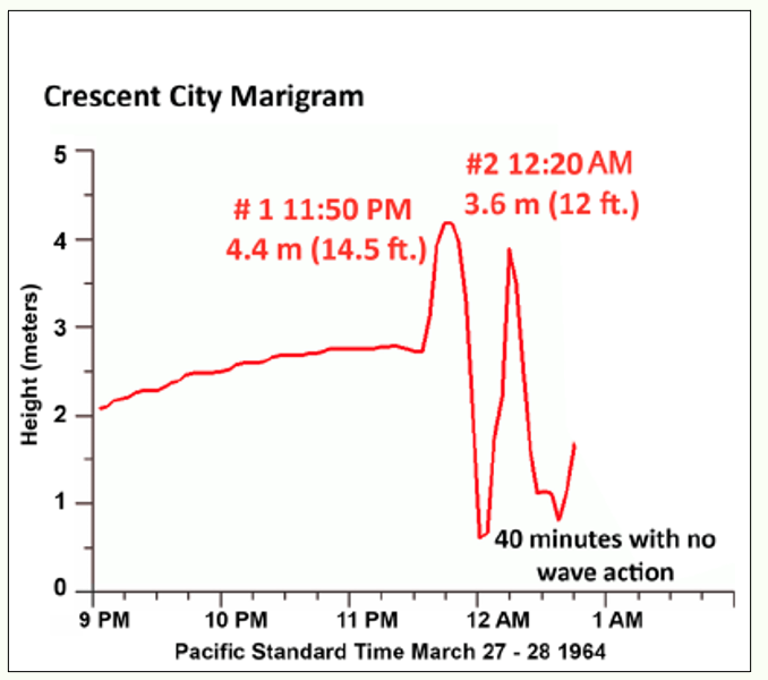
After the second surge, about 40 minutes elapses with no wave action. This is the point when some survivors reported returning to the coastal area. They assumed the tsunami was over, in part based on what they had experienced in the 1960 tsunami.
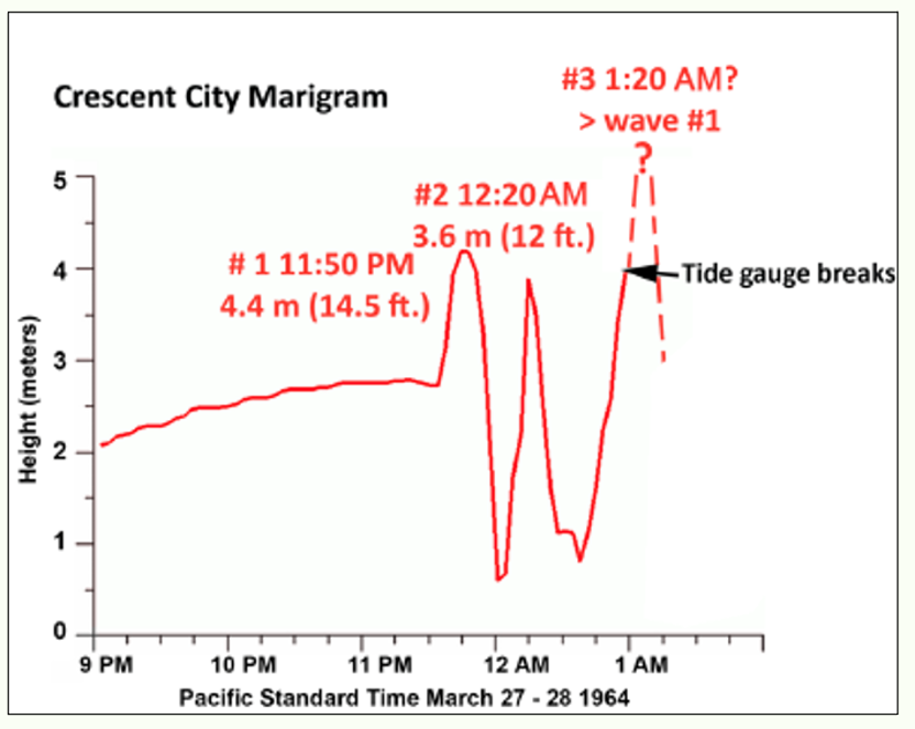
At a little before 1 AM, a third surge begins and the water quickly rises, surpassing the first surge and knocking the tide gauge housing over. After this point, the tsunami behavior is uncertain (shown by dashed line). Most survivors described four major surges and the fourth was the largest. After the third surge, the harbor drained completely and people could see the seafloor in the moonlight.
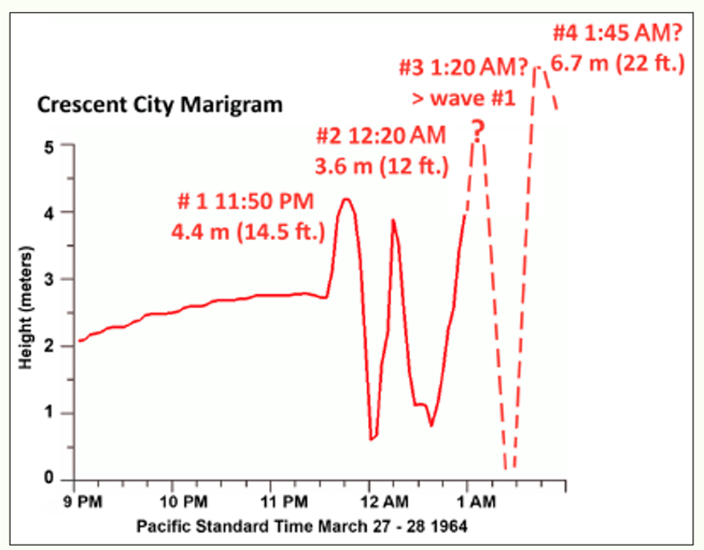
Most of the eyewitness accounts report the fourth surge was the highest. It was just high enough to top the sea barrier on the west side of Crescent Harbor, an amplitude of 15.7 feet. The tide was still relatively high and boosted the peak water elevation to nearly 22 feet. Smaller surges likely continued in the harbor for days but never came close to the size of that fourth surge.
Peggy Coons and her husband were the lighthouse keepers of Battery Point and described the fourth surge,
“Suddenly there it was, a mammoth wall of water barreling in toward us, a terrifying mass of destruction, stretching from the floor of the ocean upwards: it looked much higher than the island, black in the moonlight. Roxey shouted, "Let’s head for the tower." It was too late. As we turned toward the tower, he yelled, "Look out!" We both ducked. It struck, split and swirled around both sides of the island with such speed we felt like we were sailing right along with it. It took several minutes for us to realize the island hadn’t moved. It crashed into the shore, picking up the driftwood logs and other debris lodged in our roadway and along the beachfront. It looked as though it would push them on the pavement at the end of A street leading past the Seaside Hospital.”
Read Peggy Coons’ complete description of the 1964 tsunami here.
This CBS news report with Terry Drinkwater gives a feel of the impacts in Crescent City.
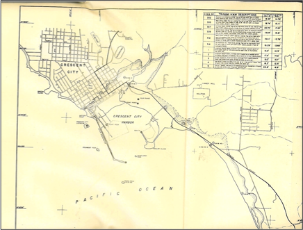
The Drinkwater story overstates the area affected and understates how high the water reached. Orville Magoon of the US Army Corps of Engineers did a detailed study of the Crescent City area and mapped the extent of inundation and structural damage.
That mapped area is presented in the image below, noted by the shaded region along the coastline. The flooding coverd 29 city bocks.
Crescent City's Tsunami Walk, shares survivor accounts of what happened in 1964. To hear the accounts, take the Tsunami Walk below.
The tsunami elsewhere in California
The tsunami was recorded on tide gauges throughout the State. Damage was reported as far south as Half Moon Bay. Strong currents caused at least 17 million (in 1964 $$) in the San Francisco Bay Area.
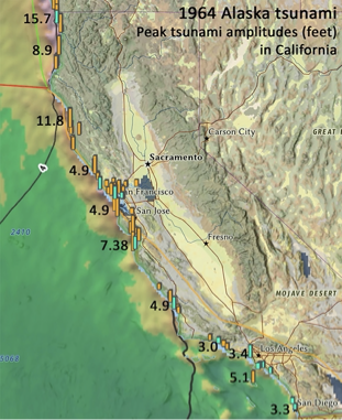
This map shows peak tsunami amplitudes in feet at California coastal locations. Data provided from the National Center for Environmental Information. An interactive map of all of the tsunami heights reported after the 1964 earthquake can be found here https://www.ncei.noaa.gov/maps/hazards/?tsEvent=1954
Reconstruction in Crescent City
The Army Corps of Engineers established a recovery zone covering most of the downtown area within the inundation zones. Almost all of the buildings within that zone, whether damaged or not, were removed. Second Street had been the heart of the City before the tsunami. Three blocks were removed and replaced with open space and a walkway.
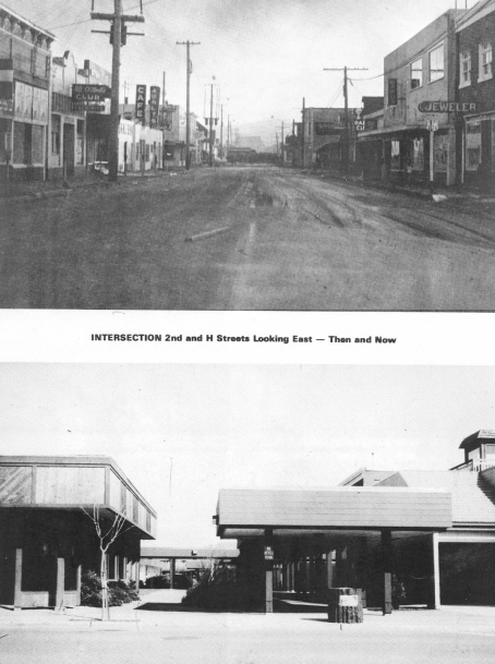
These comparison photos are from Dark Disaster, a remembrance of the 1964 tsunami published on the 20th anniversary of the disaster. The views are of Second Street looking east. Before the tsunami (top photo), this was the heart of downtown Crescent City with many businesses. After the Army Corps of Engineers’ reconstruction, it was replaced with a pedestrian walkway and open area. No businesses returned to the area.
Changes in the U.S. Tsunami Warning System after 1964
- 1967 three regional sites in Alaska were tasked with providing tsunami threat information to Alaska communities. One of them, in Palmer Alaska, would take over this responsibility for the State.
- 1968 tsunami operations move from Honolulu Observatory to Ewa Beach and becomes the Pacific Tsunami Warning Center (PTWC).
- 1982 Palmer given responsibility for issuing alerts to Alaska or the West Coast for earthquakes centered in Alaska or the West Coast
- 1996 Palmer responsible for all alerts to Alaska/West Coast - becomes West Coast Alaska Tsunami Warning Center (WCATWC)
- 2013 Name is changed to the National Tsunami Warning Center (NTWC)
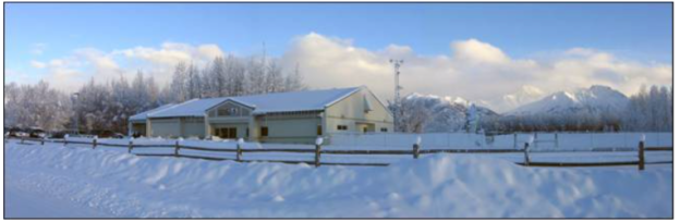
The National Tsunami Warning Center in Palmer, Alaska in 2021.
More about the history of NTWC at https://www.tsunami.gov/?page=history
As of 2024, the U.S. maintains two tsunami warning centers. NTWC has responsibility for monitoring Pacific earthquakes and issuing alerts to Alaska, both U.S. mainland coastlines, and Canada. PTWC is responsible for Hawaii, U.S. territories, and nations in the Pacific that are part of UNESCO’s Intergovernmental Oceanographic Commission.
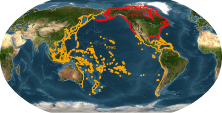
Areas of Responsibility in 2024 for U.S. tsunami warning centers. Coastlines in red are under jurisdiction of NTWC; coastlines in orange receive information from PTWC.
Improvements in detection and dissemination of tsunami information
- Both tsunami warning centers operate 24/7 with hardened communication systems
- Real time seismic and water level data
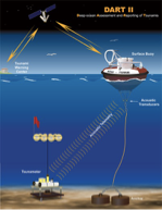
- DART system of deep ocean water level instruments provide ability to forecast peak tsunami amplitudes - https://nctr.pmel.noaa.gov/Dart/
Improvements in hazard assessment and outreach
- Evacuation maps for most west coast locations - https://rctwg.humboldt.edu/tsunami-hazard-maps
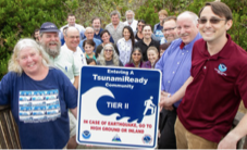
- TsunamiReady program strengthening ability of coastal communities to receive tsunami alerts and disseminate
- Exercises for emergency managers
- Numerous tsunami preparedness and outreach programs https://rctwg.humboldt.edu/prepare/now
What would happen if the 1964 Alaska earthquake occurred today?
First bulletin from NTWC would be issued within 4 minutes of the earthquake. Alaska coastlines would be placed in a Tsunami Warning and West Coast locations in a Watch. Message would include estimated arrival times for coastlines in Alaska and along the West Coast. Message would be sent to all counties and be posted on tsunami.gov.
Additional bulletins would be issued every half hour. California areas would be placed in a Tsunami Warning if data supported a significant tsunami and arrival time approached three hours.
Counties and state emergency personnel would hold hourly conference calls with NTWC personnel to discuss confidence in the forecasts.
Counties would decide evacuation areas and order evacuations if a Tsunami Warning were in place.
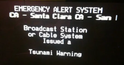
Emergency Alert System and Wireless Emergency Alert Systems would be activated - notifications sent to phones, cell phones, computers, interruption of normal programing on local TV and radio stations. Door to door notification if time permitted.
References/links:
Advances in Earth Sciences resulting from the 1964 earthquake and tsunami https://agupubs.onlinelibrary.wiley.com/doi/pdf/10.1002/2014EO170001
Ground failure in the Anchorage area https://pubs.usgs.gov/pp/0542a/pp542a_text.pdf
Eyewitness accounts of the Turnagain Heights landslide https://www.adn.com/our-alaska/article/march-27-1964-day-earth-fell-pieces-one-anchorage-family/2014/03/23/
Eyewitness accounts from Crescent City Dark Disaster - available at https://delnortehistory.org/product-category/books/
Survivor accounts from Kodiak Alaska https://www.anchoragememories.com/1964-alaska-earthquake-tsunami.html