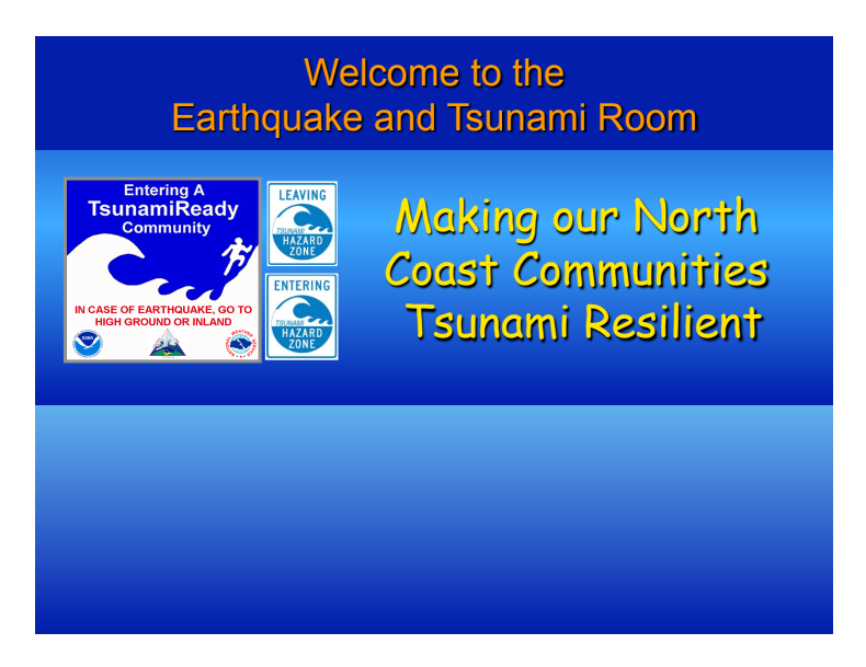
Welcome to the Redwood Coast Tsunami Work Group’s Virtual Fair!
Please come into the room and learn about the earthquake and tsunami hazards on California’s North Coast and what you can do today to make you and your family safe. By entering our room, you have taken the important first step.
Now explore!
Select the balloons below in our virtual room photo to see the latest tsunami hazard maps, earthquakes happening right now and much more.
And just like at the real fair, we welcome your questions.
Or browse our Frequently Asked Questions Page
Photo Tour of the RCTWG Virtual Fair
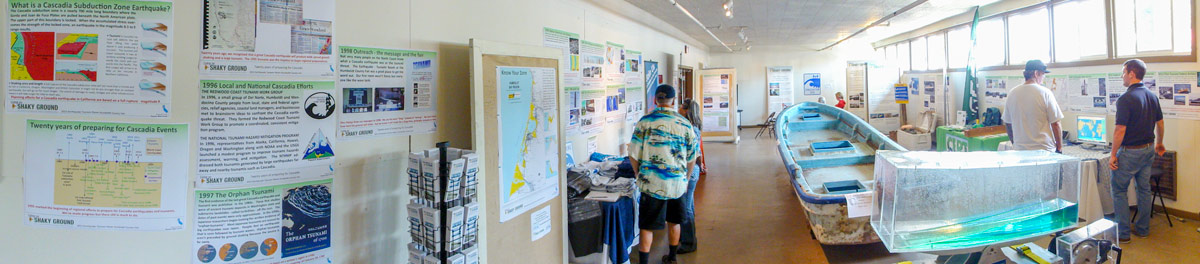
1. Know your zone! | 2. Real-Time Earthquake Map | 3. About Tsunamis | 4. Preparing Your Family & Community | 5. Tsunami Debris | 6. Kids Corner | 7. Takeaways & Talking Points | 8. Movie Corner | 9. Resources | 10. Check out the Archive!
1
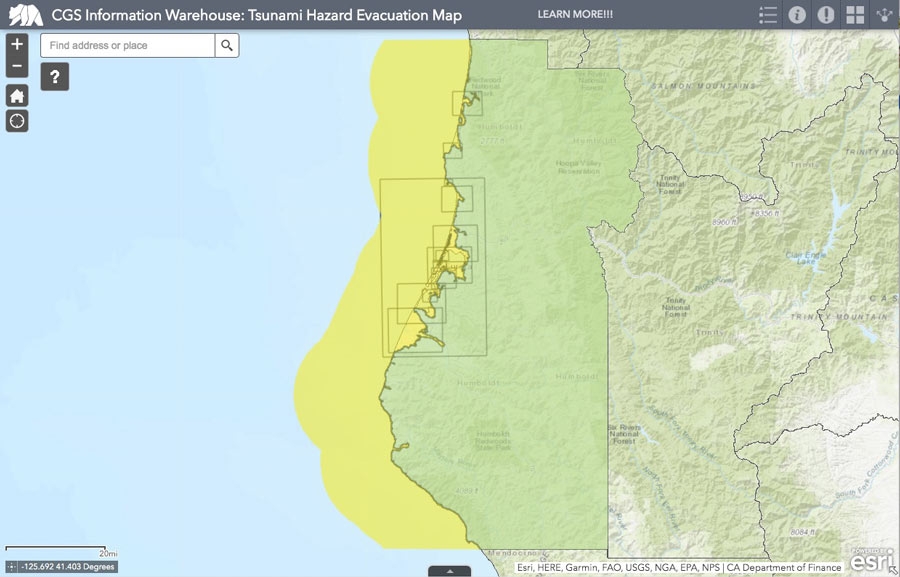
Know your zone!
The first step to being prepared is knowing the hazard zones in your area.
Familiarize yourself with the interactive map, printable maps, and tsunami signs below.
CGS Interactive Map of Humboldt County Watch a video on how to use the map
NOTE: In 2020, the California Geological Survey released new maps for Humboldt County and there was a significant update to the colors used on the maps. Also, keep in mind, these maps are based on a magnitude 9 earthquake which would produce the largest tsunami likely to impact the Cascadia subduction zone.
New Tsunami Hazard Maps are also being developed for sections of California's coastline. If you don't see your county on the map now, check back soon.
Humboldt County - Interactive PDF
This map contains all Humboldt city maps in an interactive PDF.

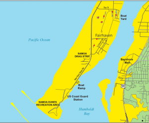
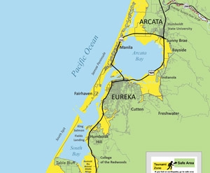
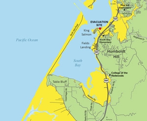
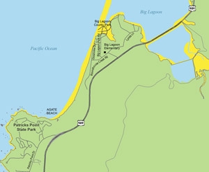
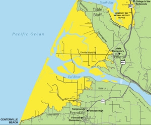
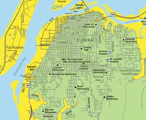
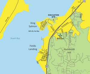
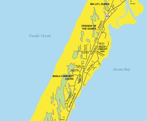
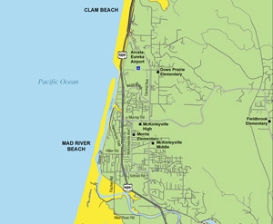
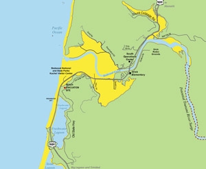
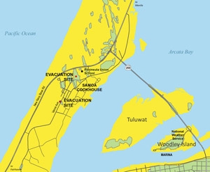
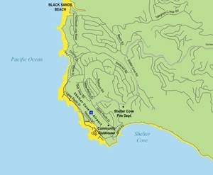
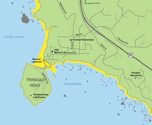
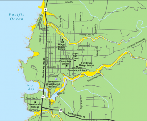
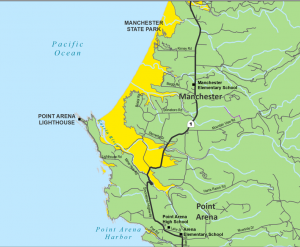
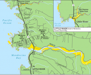
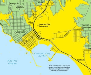
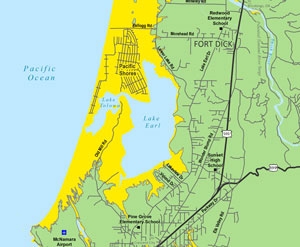
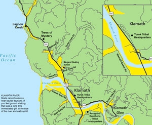
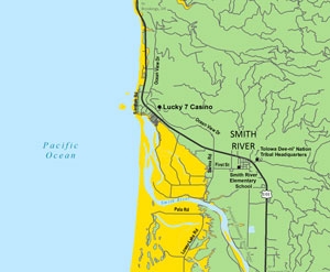
Evacuation Maps by Community
These maps will show you which sections of your town MIGHT be hazardous during a tsunami.
Explore our Tsunami Hazard Maps page or select your community below to view a larger map.

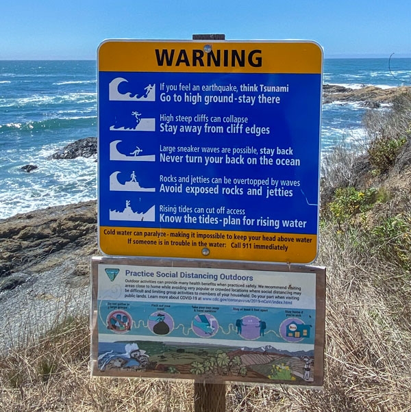
Keep an eye out for Tsunami Signs!
When you visit coastal areas, look for tsunami signs.
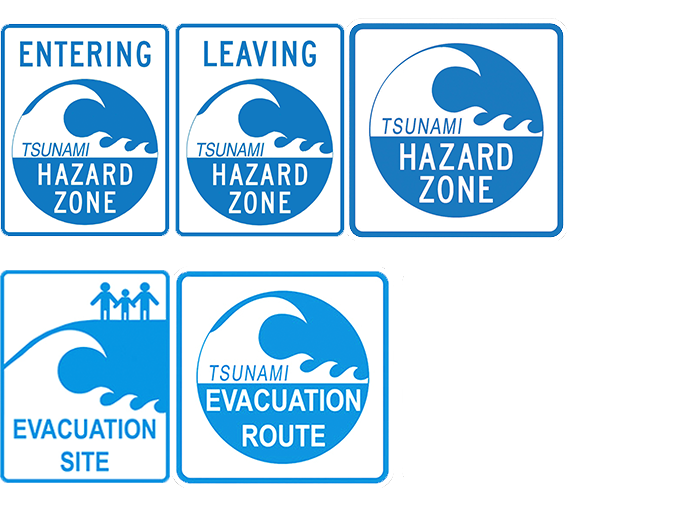
On roads and highways, you should see ENTERING and LEAVING tsunami zone signs that roughly correspond to the hazard zone boundary on the maps.
Additional HAZARD zone signs are posted on roads within the zone to remind you that a tsunami could affect you at these locations. At coastal recreation and parking areas or along trails you may see beach hazards signs that include information about multiple hazards such as tsunamis, sneaker waves, and changing tides..
In some areas, EVACUATION ROUTE signs are posted to help guide you to safe areas and in some places to an EVACUATION SITE.
2
Real-Time Earthquake Map
See what’s shaking right now!
The US Geological Survey is responsible for monitoring earthquakes in the United States and around the world. Earthquake information is posted within a few minutes of any earthquake. This is done by analyzing seismic data from instruments in the US and around the world.
Visit the world map below and see where earthquakes are occurring right now.
See what's shaking at Berkeley's Jacoby Creek Seismic Station (JCC) located five miles southeast of the HSU campus.
Want to see more seismograms? Visit the UC Berkeley Northern California network to view what's shaking right now on seismic stations throughout the northern part of the state. Follow the steps below to view the seismograms:
- Click on a station (blue square) on map.
- Select all in the pop-up window.
- Then fetch plot. Give it a minute to create the seismograms.
- Scoll down to view what's shaking!
Hear the latest daily earthquake report*
by Dr. Lori Dengler
* Initial reports are preliminary and the location and magnitude might change slightly as seismologists examine the data.
Daily Earthquake Update
-
Friday, February 6, 2026 - 2:39pm
View the last 5 days of recordings on kamome.humboldt.edu/resources.
3
Learning About Tsunamis
Tsunamis can be very powerful!
A tsunami is different from the typical waves you see at the beach. Most ocean waves are caused by wind blowing across the sea surface. Tsunamis are caused when an earthquake or other event like a landslide moves the entire water column from the seafloor to the ocean surface. This produces a wave (also called a surge) of water that moves out in all directions, and these surges are capable of impacting areas far from where they began. This all means that tsunamis can be much more powerful and travel much faster than typical wind-driven waves. Tsunamis are also known to travel faster in deeper water which is how they are able to travel from Japan to the California coastline in about 9 hours.
As a result, we can have local tsunamis as well as distant tsunamis. On California's north coast, a local tsunami would be produced by a local earthquake. A distant tsunami could be produced by an earthquake somehwere else throughout the Pacific Ocean and travel to our shores.
There are both natural and official warnings for tsunamis.
Natural warnings, like the ground shaking for a long time, are important signs to pay attention to as they could indicate a tsunami arrival within minutes. The best thing to do is to head to high ground and stay there. Listen to Dr. Lori Dengler as she describes what to do if you experience an earthquake followed by a tsunami.
Official warnings are used when we have time to prepare for approaching tsunamis, meaning they are coming from distant locations. These are issued by the Tsunami Warning Centers and carried out by local officials. To hear about offical warnings and learn about warning centers, listen to this podcast.
How tsunamis are created...
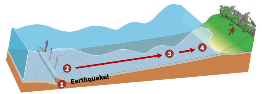
1 A plate shifts abruptly, causing an earthquake and displacing water.
2 Waves are generated and move out in all directions across the ocean, some traveling faster than 500 mph.
3 Waves enter shallow water. They compress, their speed slows, and they build in height.
4 Wave height increases and associated currents intensify, becoming threats to life and property.
How fast do the waves travel?
The animation below shows you the tsunami surges as they made their way across the Pacific Ocean after the 2011 Japan earthquake. Computer models are used to help us understand tsunami travel, and in this animation you can see that as the tsunami moves across the ocean the height of the surge is rather small. It reaches California’s coastline in about 9 hours which means that it was traveling very fast across that deep ocean.
What happens when the waves hit the shore?
Once the surges begin approaching the shore and the water depth changes, the surge height and speed changes as well. This is when we begin to see strong currents and water flowing over the land in some cases. The video below helps us visualize how the tsunami changes as it approaches shore.
4
Preparing Your Family & Community
Now that you've learned about your local tsunami zones, we've assembled four important tips to help get you prepared.
Earthquakes and tsunamis can be alarming and disorienting, but we can take small steps to be more prepared emotionally and mentally so when a tsunami occurs we have the muscle memory to know what to do.
TIP 1
What to do during an earthquake and/or tsunami?
It's as simple as doing the actions shown below.

Check out our preparedness triad in other languages, too. Learn the steps in 13 different languages!
TIP 2
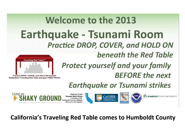
Practice earthquake and tsunami drills!
Join the Great ShakeOut on October 20th!
Register your family, friends, and place of business at shakeout.org!
Remember, participating can be fun and easy! Join the HSU Geoscience students while they participate this year and explain why you should take the time to ShakeOut.
Watch the Student PSA [VIDEO]

Visit tsunamizone.org and register to participate in tsunami preparedness activities as well!
World Tsunami Awareness Day is November 5th and Tsunami Awareness week will be in March 2023.
TIP 3
Sign up for emergency alerts
All California counties have emergency notification systems. To find yours, search emergency notification along with your county name. Below you'll find the links for the north coast counties. Visit the sites to learn how to sign up for emegency alerts and messages where you live.
Del Norte County
Humboldt County
Mendocino County
The state also has an earthquake alert system!
Sign up for the Earthquake Warning California alerts and download the app to your phone to get notifications right away.
TIP 4
Learn about Community Emergency Response Teams (CERT)
![]()
Organizations like CERT have great resources to help when practicing earthquake drills, preparing emergency plans, collecting supplies, and learning about potential hazards.
Humboldt CERT Coalition website
Watch the Humboldt Bay CERT Coalition video.
5
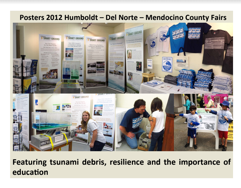
Tsunami Debris
What happens to all the stuff that is washed away in a tsunami?
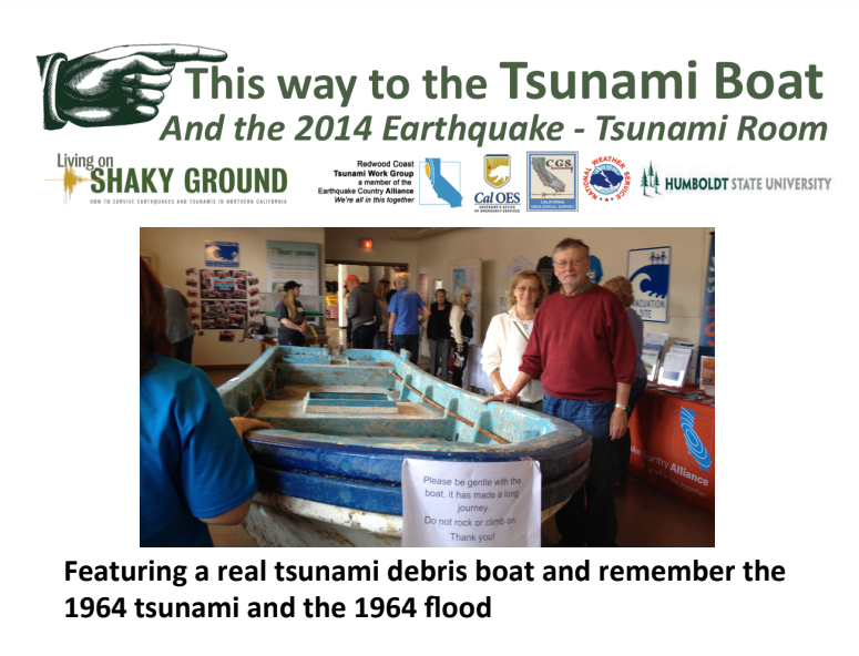
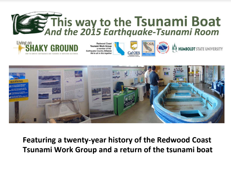
The 2011 Japan tsunami was a lesson on what happens to debris that gets pulled far enough offshore to become part of the Pacific-wide circulation. Boats, refrigerators, parts of shrines, a dock, and even a motorcycle were found washed up on shores in Alaska, Hawaii, British Columbia and the Pacific Northwest. Two small boats washed ashore in northern California and their registration numbers linked them back to the tsunami and Japan. Kamome landed in Crescent City in April 2013 and Tai Shu Maru landed in Dry Lagoon in June 2014. Check out the resources below to learn more about these boats.
The journey of Kamome is a heartwarming story of a little boat who connected high school students and communities. Read about this journey at The Story of Kamome
Take a virtual tour of Del Norte County and plan a visit to see the sights Visit Del Norte County
Explore the region where Kamome landed and read about the lives impacted The Story of Kamome in Crescent City
Take a virtual tour of the Tai Shu Maru and learn about other tsunami debris Meet the Tai Shu Maru
What to do if you find debris after a tsunami:
1. Ask yourself if it’s hazardous or not
- If it is hazardous, call 911. Things like oil or chemical drums, gas cans or propane tanks could pose a hazard and should be reported to the authorities as soon as possible.
- If it isn’t hazardous, contact the U.S Coast Guard National Response Center at 1-800-424-8802 or email your observations to DisasterDebris@noaa.gov
2. Ask yourself if you should pick it up and pack it out
If you don’t know what it is, don’t touch it. Report it to the authorities so it can be dealt with appropriately.
If it's ordinary beach debris and you have the means, pack that trash out with you. Let’s leave the beaches cleaner than they were when we arrived.
Printable version of this information
Watch how the debris from the 2011 Japan Tsunami traveled across the Pacific Ocean.
6
Kids Corner
It’s important to get the whole family involved!
Below you will find a few resources and tools to get you started:
You can also find many other resources on the Extraordinary Voyage of Kamome website or follow the links below for Tsunami preparedness activities by grade which are also a part of our curicculum on the Kamome website.
7
Takeaways & Talking Points
Below you’ll find some of our key takeaway messages.
These quick-guides will describe how to know if a tsunami is coming, how to read the tsunami evacuation maps, and will provide you with the steps to be prepared for earthquakes and tsunamis.
You can also find these takeaways and talking points in Spanish below.
8
Movie Corner
Sit back, relax, and enjoy some short videos about earthquakes and tsunamis.
Check out the videos below to learn more about earthquakes and tsunamis:
- Follow along with Sue Nami as you learn about her hazards.
- NOAA's Tsunamis - Be prepared & stay safe!
- Dr. Dengler's Keynote Presentation at Tokyo Museum
- Reflections on the 1964 Tsunami in Crescent City, CA
- Dr. Dengler's Presentation - The Whys of Earthquakes and Tsunamis on the North Coast
Building Connections & Learning from Each Other
- Amya Miller's Story
- Recovering Hope - connections between Crescent City & Rikuzentakata
- The Friendship that a Boat Carried
Planning & Testing the Local Warning Systems
Explore Humboldt County's "Ask An Expert" playlist!
- Do Small Earthquakes Help Prevent the Big One?
- Are We Overdue for the "Big One?"
- How Do I Know That a Tsunami is Coming?
- How Likely Are We to See the "Big One" in Our Lifetime?
- How Were the Tsunami Hazard Zones and Safe Areas Determined?
- If an Earthquake Knocks Out Cell Towers, How Will I Know That a Tsunami is Coming?
- How Will We Drive Out of a Tsunami Zone When All of the Roads Are Closed?
- What is the Likely Scenario for a Really Big Tsunami to Hit Shelter Cove?
- Of the Land-Based Faults, What is the Most Likely One to Cause an Earthquake?
- Shouldn't We Evacuate Further Inland to be Safe?
- What is Liquefaction and Will the Ground Sink After an Earthquake?
- Where Would Our Largest Tsunami Come From and How Much Time is There to Evacuate?
- Who Issues Tsunami Warnings?
- Why Aren't Tsunami Sirens Along the Entire Coast?
KEET Earthquake & Tsunami Preparedness PSAs
The First "Sue Nami"
9
Resources
Below you will find resources to help you prepare.
You will find Tsunami Evacuation Map Brochures for your community, a downloadable version of the Living on Shaky Ground magazine, and a copy of our magnet graphic (Triad) that will give you a daily reminder about the steps for safety: drop, cover, and hold on; get to high ground; and stay there!
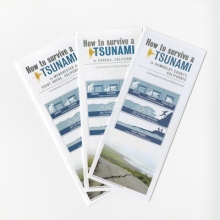
Tsunami Brochures - Mendocino
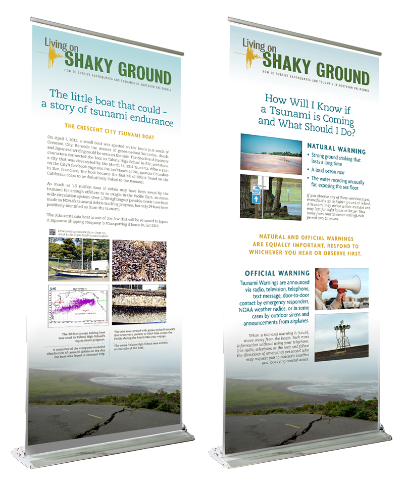
Living on Shaky Ground
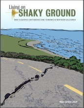
A magazing on how to prepare for the earthquakes and tsunamis.
Preparedness Triad
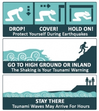
This preparedness triad is available in 13 different languages!
10
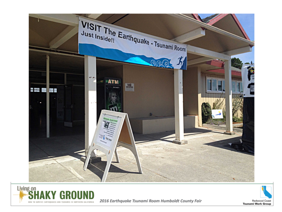
Check out the archive!
Take a step back in time by checking out our past fairs.
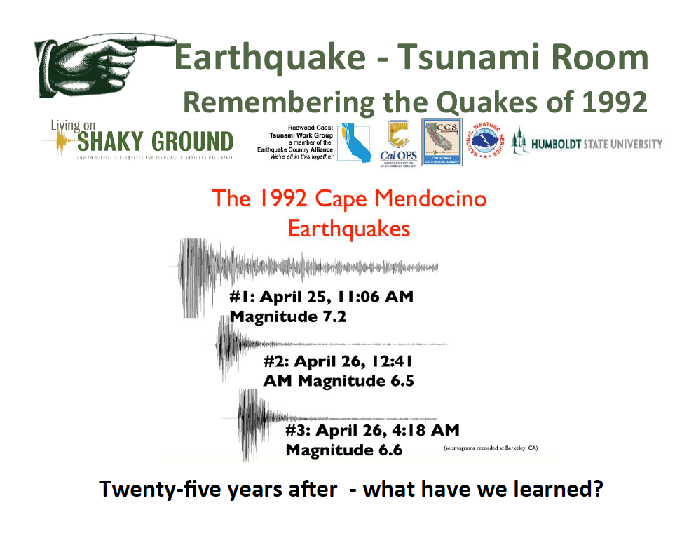
The Earthquake and Tsunami Room has been a feature at the Humboldt County Fair for many years. Enter our archive to visit a past fair. We’ve assembled our previous resources for you to explore regarding events like the 1964 Great Alaska earthquake and tsunami, the 2011 Japan earthquake and tsunami as well as many others.
THANK YOU
Several organizations and many individuals contributed to the RCTWG Virtual Fair. Financial support was provided by the California Office of Emergency Services Earthquake and Tsunami Program. Kamome curriculum and web page supported by the California Seismic Safety Commission.We thank members of the HSU Marketing & Communications team for web design, publicity, and technical assistance. Content for the Virtual Fair was provided by Lori Dengler, Amanda Admire, Vicki Ozaki, Linda Nellist, and the members of the HSU Geosciences capstone course. Numerous members of the RCTWG reviewed the site. And we thank all of you for visiting our fair and welcome your feedback.