Cape Mendocino Earthquakes 1992
Join us on a virtual tour of the Mendocino triple junction. This region is known for its stunning vistas and frequent earthquake activity. Let’s learn a bit more about what makes this region so unique and how earthquakes help to tell us more about that story. Funding for this video was provided by the National Earthquake Hazards Reduction Program (NEHRP). Video created and produced by Thomas B. Dunklin.
The 1992 Cape Mendocino Earthquakes
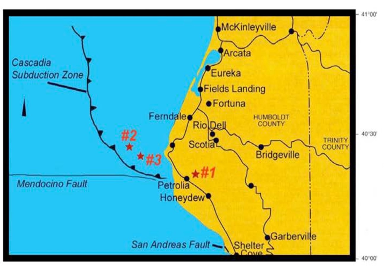
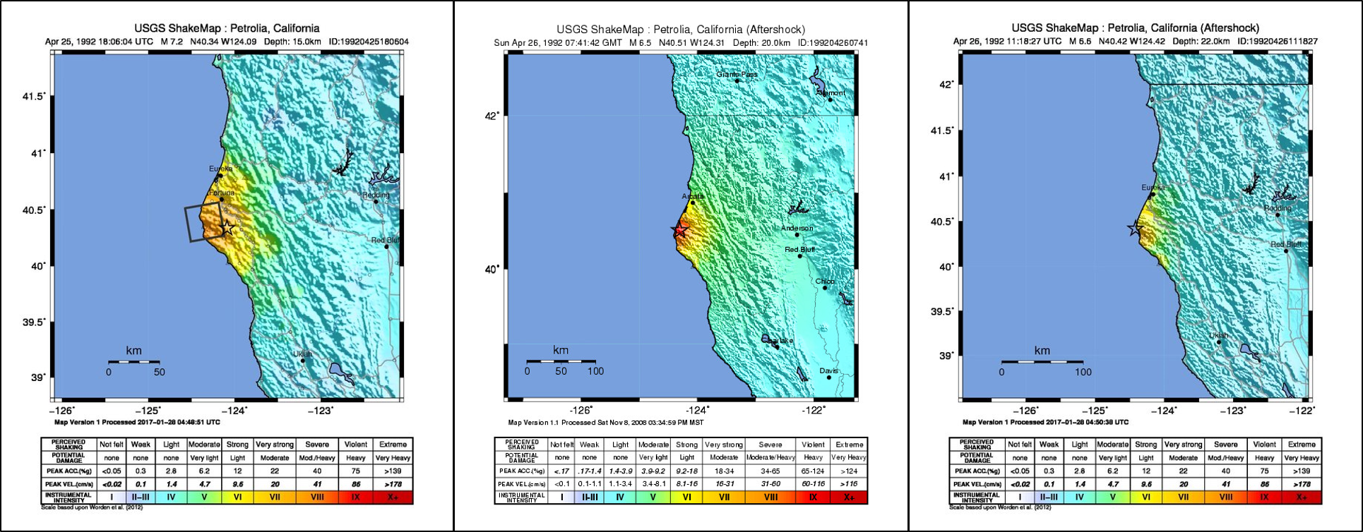
On April 25, 1992, a sequence of earthquakes began on Cape Mendocino resulting in widespread felt shaking and damage across Humboldt County. There were three significant earthquakes included in this sequence. The first was the largest at a magnitude 7.2 and it occurred at 11:06 am on April 25th. It was located 3 miles east of Petrolia, CA at a depth of 8 miles beneath the surface. This was followed by a magnitude 6.5 aftershock at 12:41 am on April 26th located 17 miles west-northwest of Petrolia. The second aftershock, a magnitude 6.5, occurred at 4:18 am on April 26th centered 16 miles west of Petrolia.
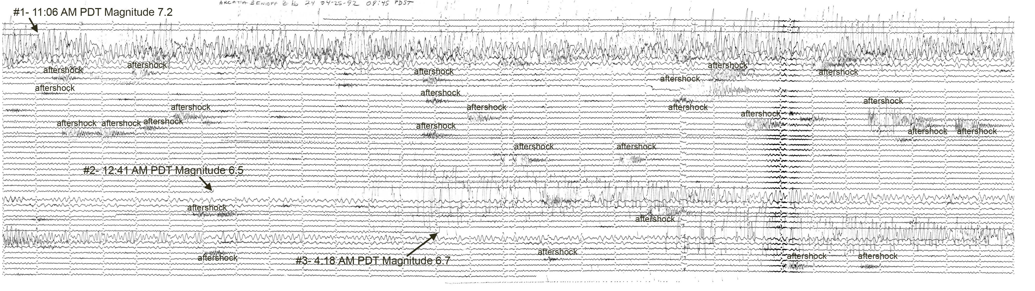
The earthquakes were large enough to be recorded by seismographs around the globe. The seismogram below is from the instrument in the basement of Founders Hall on the Cal Poly Humboldt campus. The onset of the three main earthquakes and a number of the smaller aftershocks is labeled. These earthquakes were centered about 40 miles away from this seismograph.
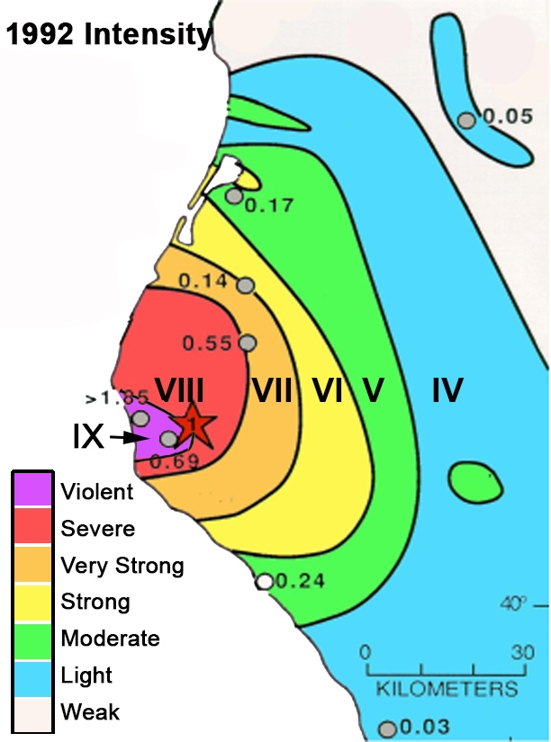
The first earthquake was felt from south of the San Francisco Bay Area to Southern Oregon. This is an isoseismal map (contours of equal shaking) compiled from over 2000 survey responses and damage mapping of the region.
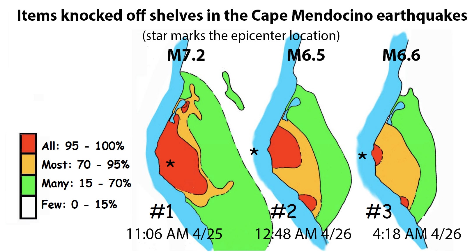
The M6.5 and M6.6 aftershocks were also felt widely. These earthquakes were on faults in the Gorda plate and oriented in a different direction than the M7.2 mainshock. They directed more energy to the south and were strong enough to wake people sleeping as far away as Salinas. These maps compare the relative shaking strength of the three biggest earthquakes by contouring the relative number of items reported knocked off shelves.
The USGS compiled ShakeMaps for each of these earthquakes based on instrumental recordings. Because there were relatively few strong motion instruments in the area at the time, the ShakeMaps don't show the detail of the isoseismal maps, but show a similar pattern.

The M7.2 mainshock produced the strongest accelerations ever recorded in a California earthquake. The accelerometer at Cape Mendocino peak vertical acceleration was just under twice the value of gravity. It was strong enough to throw heavy items into the air such as this Caterpillar tractor in the same area as the accelerometer. It had been sitting idle all winter, mired in the mud. During the earthquake it bounced into the air and settled down about a foot away without leaving a track in the mud.
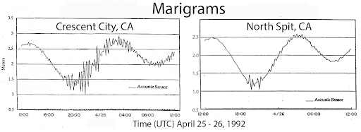
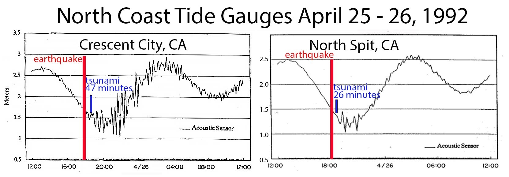
This earthquake sequence also produced a tsunami that was recorded in Crescent City and Humboldt Bay.
Geologic Setting of the North Coast
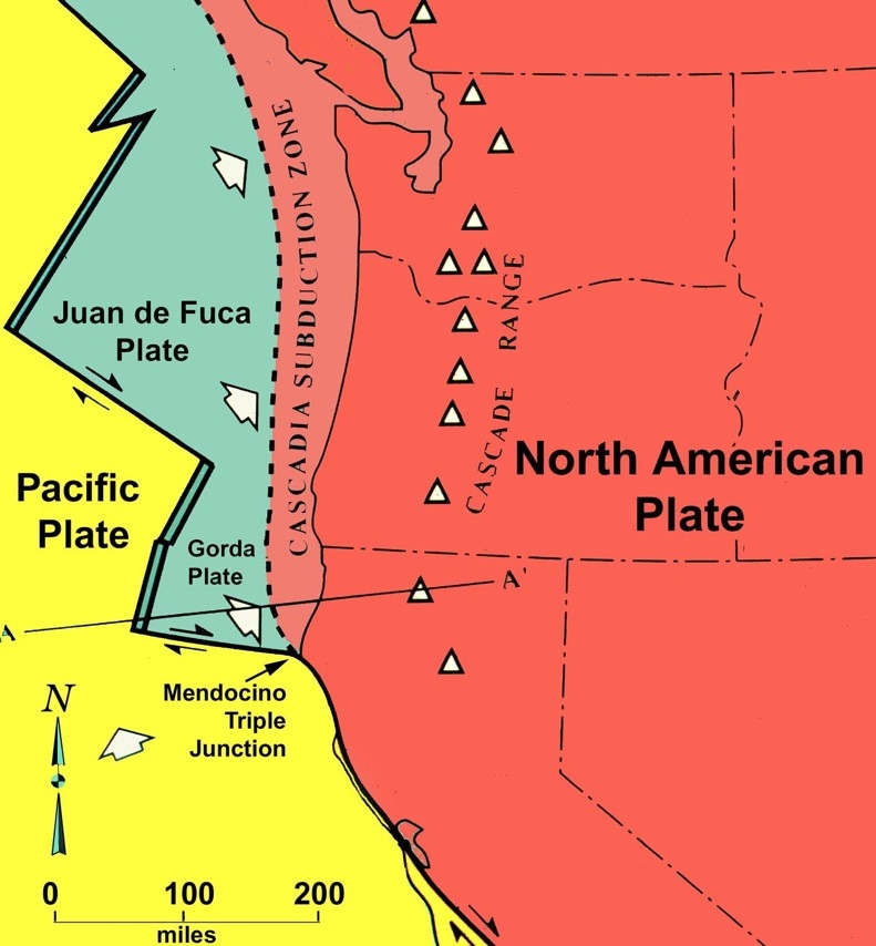
Cape Mendocino is located in a dynamic and active tectonic environment. Located at the southern end of the Cascadia subduction zone, Cape Mendocino is positioned in a region known as the Mendocino triple junction. A triple junction is a place where three tectonic plates meet, and in this region those plates are the Gorda, the Pacific, and the North American.
While this map notes the Mendocino triple junction as a point, it’s actually a region that extends from Punta Gorda in the south to Cape Mendocino in the north and inland to areas as far as Petrolia or Honeydew.
The Cascadia subduction zone extends from this Mendocino triple junction region northward to Vancouver Island, British Columbia. It is formed by the subduction of the oceanic crust of the Explorer, Juan de Fuca and Gorda plates beneath the continental crust of the North American plate. This fault is capable of producing earthquakes in the range of magnitude 9.
The earthquakes of April 25th and 26th were the result of fault ruptures in the Mendocino triple junction, and not on the Cascadia subduction zone. However, it provided scientists and emergency planners an opportunity to plan and coordinate for even larger earthquakes that could impact the region.
Impact of the 1992 Earthquake Sequence
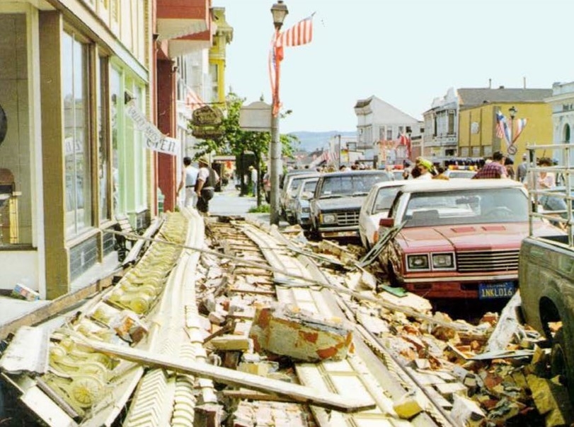
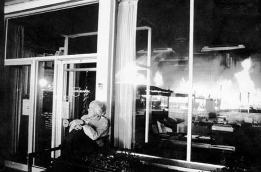
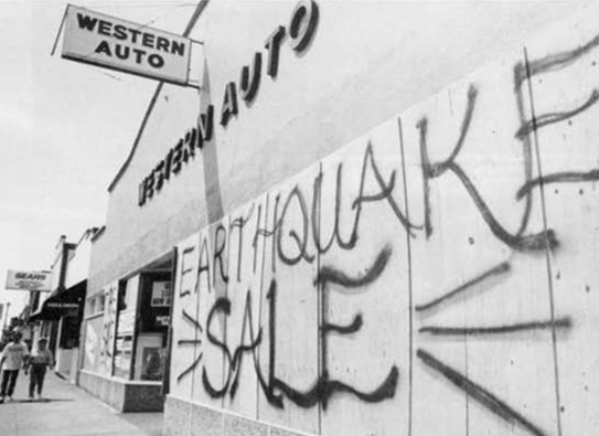
On the morning of April 25th, the mainshock of magnitude 7.2 rocked the region. It was captured on film by Ross Rowley who was in the town of Ferndale during a local parade. Damage was observed across the regions with 1,108 structures damaged or destroyed, 356 injuries, and $61 million dollars in damages.
The communities of Ferndale, Petrolia, Rio Dell, Scotia, and Fortuna were heavily affected by this earthquake sequence.
Ferndale: 36 homes seriously damaged, 20 homes knocked off foundations, 80% of business damaged. Utilities disrupted. Cost $11 million.
Petrolia: 5 homes destroyed, 28 homes experienced major damage. Post office, gas station and general store destroyed by fire. Cost $1 million.

Rio Dell: 12 homes destroyed, 57 homes experienced major damage. 75% of businesses damaged. Broken water mains and sewer pipes, water system contaminated. Cost $11 million.

Scotia: Shopping center destroyed by fire triggered by first major aftershock. 50 homes damaged. Cost $15 million.
Fortuna: Brick chimneys damaged. Many broken windows in business district. Damage to older store buildings.
Experts Discuss 30 Years of Preparedness Progress
Between 1992 and today, there has been much work done to improve earthquake and tsunami response and preparedness for communities in vulnerable areas.
Earthquake Hazard Preparedness
A detailed scenario of what the shaking hazard would produce has been developed
Earthquake hazard maps have been developed for vulnerable communities
State legislation was developed regarding seismic hazards like unreinforced masonry and real estate disclosures
A dense network of seismic stations has increased monitoring coverage of California
Earthquake early warning systems have been developed to notify people of approaching damaging seismic waves and shaking so they can take steps for safety
Dr. Peggy Hellweg gives us an overview of the advances made since 1992 regarding earthquake notifications systems. Most importantly, the Earthquake Early Warning system in California and the steps taken to notify the public of approaching damaging waves.
Tsunami Hazard Preparedness
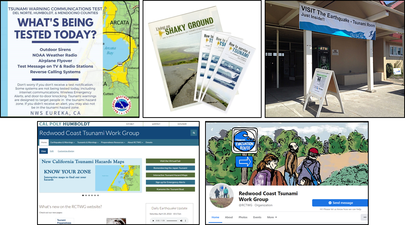
Development of the National Tsunami Hazard Mitigation Program
Creation of the Living on Shaky Ground magazine, first published in 1993 and updated frequently
Advanced mapping of offshore bathymetry to improve tsunami modeling
Improved tsunami hazard modeling programs to develop hazard maps
Tsunami hazard maps have been developed for coastal communities and are available online to all users
The Tsunami Warning Centers have developed a more rapid assessment protocol in order to deliver bulletins quickly
Tsunamis of 2004 and 2011 significantly improved the ability to perform rapid assessment of events and coordinating data
Developed outreach education tools and resources to increase awareness and preparedness. Includes performing yearly Tsunami Communications Tests in March, creating community-specific brochures, attending outreach events like county fairs and community meetings, developing and maintaining the Redwood Coast Tsunami Work Group website, and increasing awareness via social media
Dr. Lori Dengler reflects on how the Cape Mendocino earthquakes of 1992 helped us to understand the hazard of tsunamis along the North Coast. Tsunamis were not a major concern prior to 1992 in northern California; however, the April 25th event produced a tsunami recorded on the North Coast and prompted the creation of the National Tsunami Hazard Mitigation Program.
Listen along as Lori Dengler shares the Virtual Tour of the Mendocino Triple Junction. In July 2022, Lori was joined by Thomas Dunklin and Amanada Admire for an OLLI presentation at Cal Poly Humboldt.
Check out Dr. Lori Dengler's Not My Fault articles published in the Eureka Times-Standard newspaper that discuss the 1992 Cape Mendocino earthquakes and the following tsunami:
April 9, 2022: Remembering the
1992 Earthquakes
April 16, 2022: Cape Mendocino Earthquakes
Change Intensity Mapping

April 23, 2022: The 1992 Earthquake Makes
Waves in the Tsunami World
To learn more about the 1992 earthquakes and tsunami, check out the StoryMap and details shared by the California Geological Survey: