Recent earthquakes near the Mendocino triple junction
Recent North Coast Earthquake Sequences
The Mendocino triple junction is a zone of concentrated seismicity where the San Andreas Fault, the Mendocino Fault, and the Cascadia subduction zone meet. Earthquakes can occur on any of these faults and within the three plates – the Gorda plate, Pacific plate, and North American plates that interact in this region. Let's explore some of the recent significant earthquakes in the vicinity of the Mendocino triple Junction, their aftershock sequences, and how these earthquakes are related.
This video completed in 2021 by Humboldt Geology alum and videographer Thomas Dunklin takes you on a virtual field trip of the Mendocino triple junction region. It introduces you to the tectonic setting where earthquakes in 2021, 2022, and 2024 were located.
Earthquake sequences in 2021, 2022, and 2024

This map identifies three earthquake sequences. The circles are the earthquake epicenters (locations). The blue represents the two M6.0 December 20, 2021 earthquakes and aftershocks, the green represents the M6.4 December 20, 2022 earthquake and aftershocks, and the yellow represents the M7.0 December 5, 2024 earthquake and aftershocks. Data provided by USGS.
A quick comparison of three earthquake sequences

These maps give a quick comparison of the three most strongly felt earthquakes since 2021. The M6.0 2021 map is the recorded strong motions for M6.0 centered on Cape Mendocino. The earthquake and it’s M6.0 companion 11 seconds earlier were widely felt but caused only minor damage. The most damaging of the three occurred in 2022. Measured peak ground motions in Rio Del approached 1.5g and caused an estimated $92 million in damages to Rio Dell. Peak ground motions in 2024 were nearly doble the 2021 earthquake but caused only modest damage. We discuss these earthquakes in more detail below.
December 5, 2024 10:44 am PST
A magnitude 7.0 earthquake centered 33 miles west of Cape Mendocino ruptured a 30-mile segment of the easternmost section of the Mendocino fault.
The USGS ShakeAlert earthquake early warning system sent out a message via MyShake and Wireless Emergency Alert systems via email 15 seconds after the earthquake origin to cell phones from Marin County to southern Oregon to expect strong shaking.
The strongest ground motions were recorded at:
- South Bay School 0.48 g
- Cooskie Peak 0.43 g
- Ferndale Fire Station 0.37 g
- Walker ridge near Petrolia 0.37 g
- Punta Gorda 0.32 g
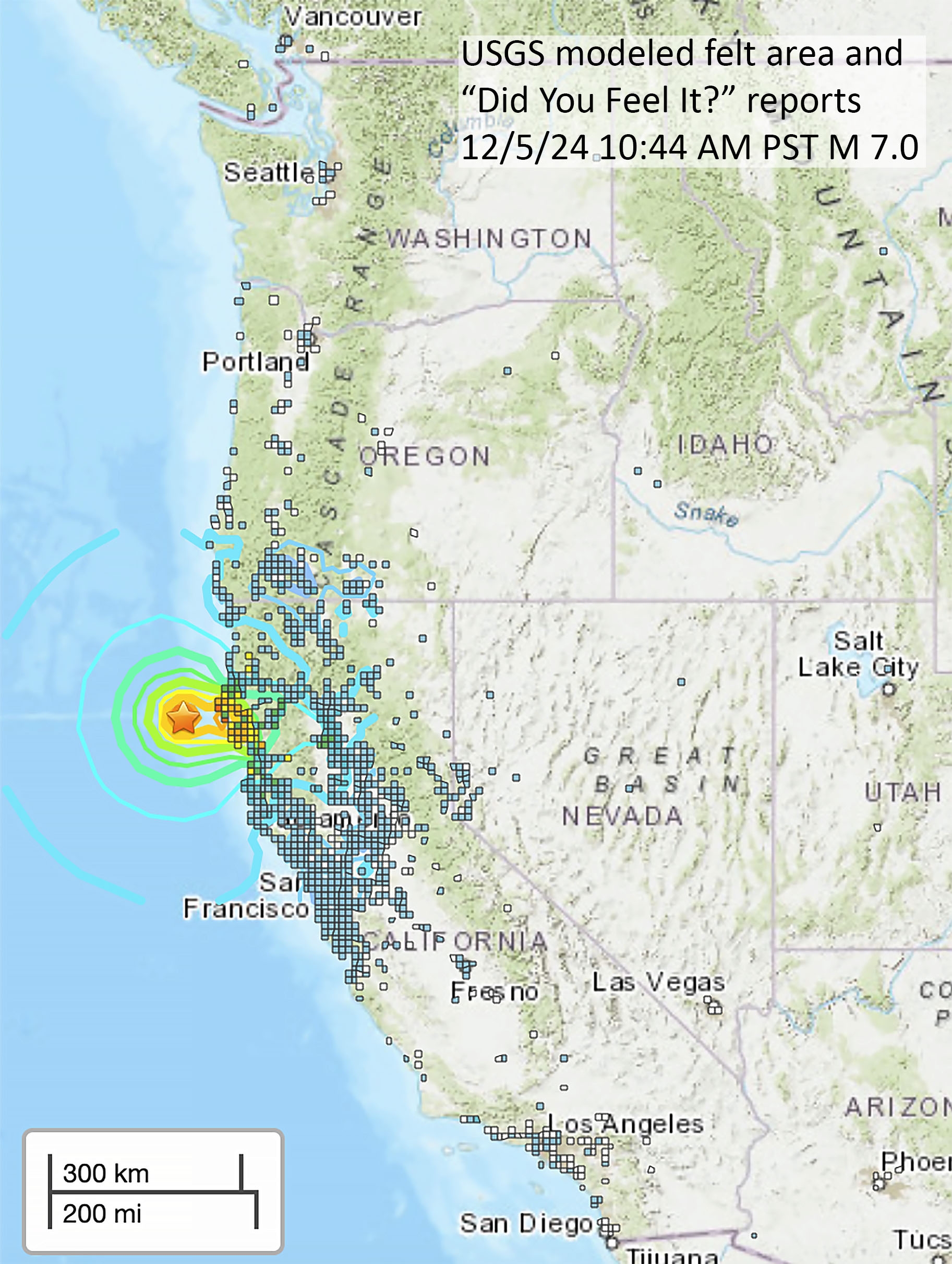
The earthquake was felt by many from Big Sur, California to Coos Bay, Oregon and by some as far away as San Diego, Seattle, and inland to Boise Idaho.

Considering the magnitude of the earthquake, damage was relatively minor. There were numerous reports of toppled items from markets and shops in the Cape Mendocino area and Southern Humboldt, but only one injury and no major damage to structures.

A chimney toppled on a home in Garberville, California. Photo provided by Lauren Schmidt.

Buisness window were broken in Garberville, California. Photo provided by Lisa Music.
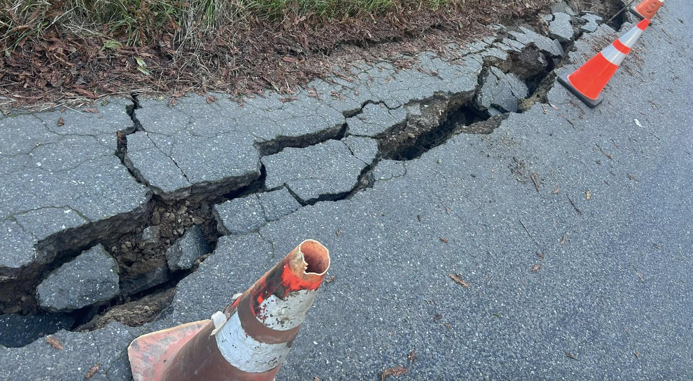
Shively Road received damage due to the shaking. Photo provided by Jessie and Brett Coleman.
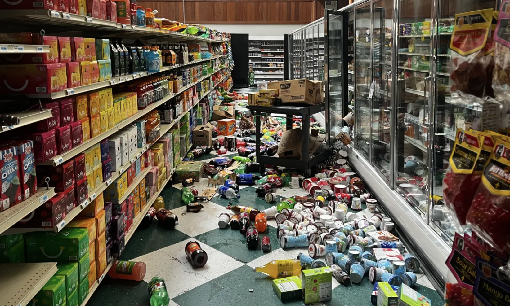
Items thrown from shelves at Hoby's Market & Deli in Scotia, California. Photo from Times-Standard.
The Tsunami and Tsunami Warning
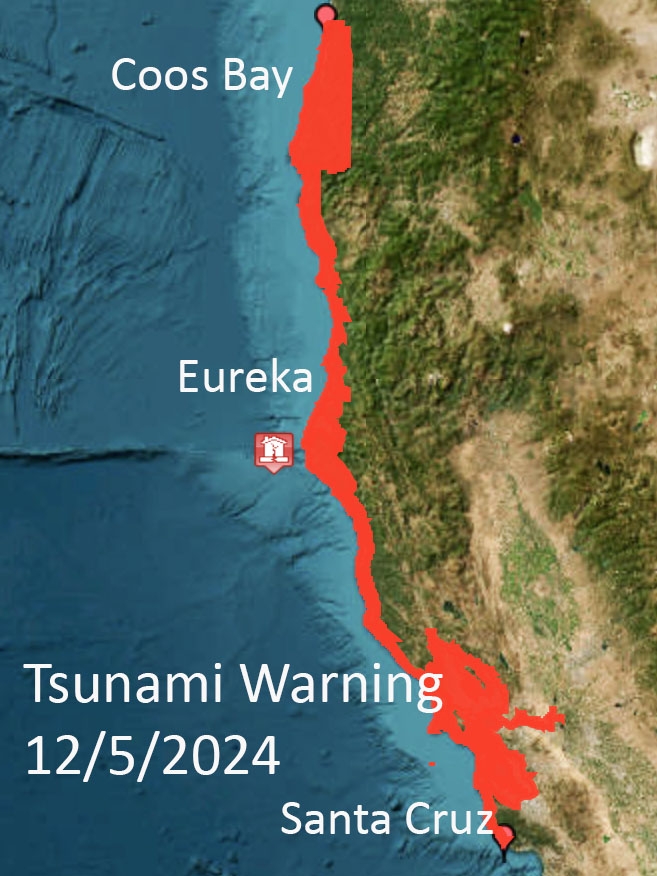
The National Weather Service (NWS) has the responsibility of assessing the tsunami potential for any earthquake that may affect U.S. states and territories. Five minutes after the earthquake the National Tsunami Warning Center (NTWC) in Palmer Alaska issued a TSUNAMI WARNING. NTWC has protocols for issuing alerts and statements whenever an earthquake likely to be widely felt or has the potential to cause a tsunami occurs anywhere in the Pacific. The initial NTWC magnitude for this earthquake was 7.3. Any earthquake offshore of the West Coast of magnitude 7.1 or larger will immediately trigger a TSUNAMI WARNING to coastlines within 250 kilometers (155 miles) of the epicenter.

It is National Weather Service operating procedure to issue tsunami forecasts to geographic areas defined by breakpoints. If the assessment of hazard extends beyond a breakpoint, the warning is extended to the next breakpoint. As a result, coastal areas from Davenport in Santa Cruz County to the Lane County – Douglas County border south of Florence, Oregon were placed within the warning zone. All communities adjacent to San Francisco Bay were also placed in the warning as there are no breakpoints between Santa Cruz and Mendocino County.
Map delineating the tsunami Warning area that was disseminated by the NTWC for the Mendocino fault earthquake. This map makes the area that was at risk much larger than it really was because NTWC uses a weather hazards map and not the tsunami hazard maps developed by the states. The true tsunami zone for the largest credible source – a magnitude 9 on the Cascadia subduction zone – would be barely discernable on the scale of this map.
Whenever a TSUNAMI WARNING is issued, the information is disseminated to coastal communities at possible risk in a number of ways including the Emergency Alert System (EAS) which broadcasts on NOAA Weather radio, emails and other alerts to county, municipal and other organizations. It is the responsibility of local jurisdictions to conduct evacuations and further dissemination of hazards information.
The December 2024 earthquake was the first time the Wireless Emergency Alert (WEA) system was used to disseminate the warning directly to the public. These messages were sent to all cell phones within the counties affected by the warning, whether they were in the mapped tsunami hazard zone or not. Approximately 8 million cell phone users received a message that looked like this.
Many people received two WEA alerts on December 5th, the first about 15 seconds after the earthquake, followed about five minutes later by the WEA tsunami warning.
ShakeAlert early earthquake warning WEA messages were sent to areas in orange over the first 40 seconds after the earthquake. Polygons show how the area expanded as the location and magnitude of the earthquake was refined. The areas in red were the counties that received the TSUNAMI WARNING WEA alert.


The Emergency Alert message issued by WEA alerting to the tsunami warning and advising people to move away from coastal waters.
Cities and communities within the tsunami zone responded to the warning in different ways. Some sent out the warning via their emergency notification systems and sounded announcements from emergency vehicles. In the San Francisco Bay Area, BART the rapid transit system shut down during the warning. On the North Coast, schools within or near the tsunami zone evacuated by foot to designated evacuation areas nearby.
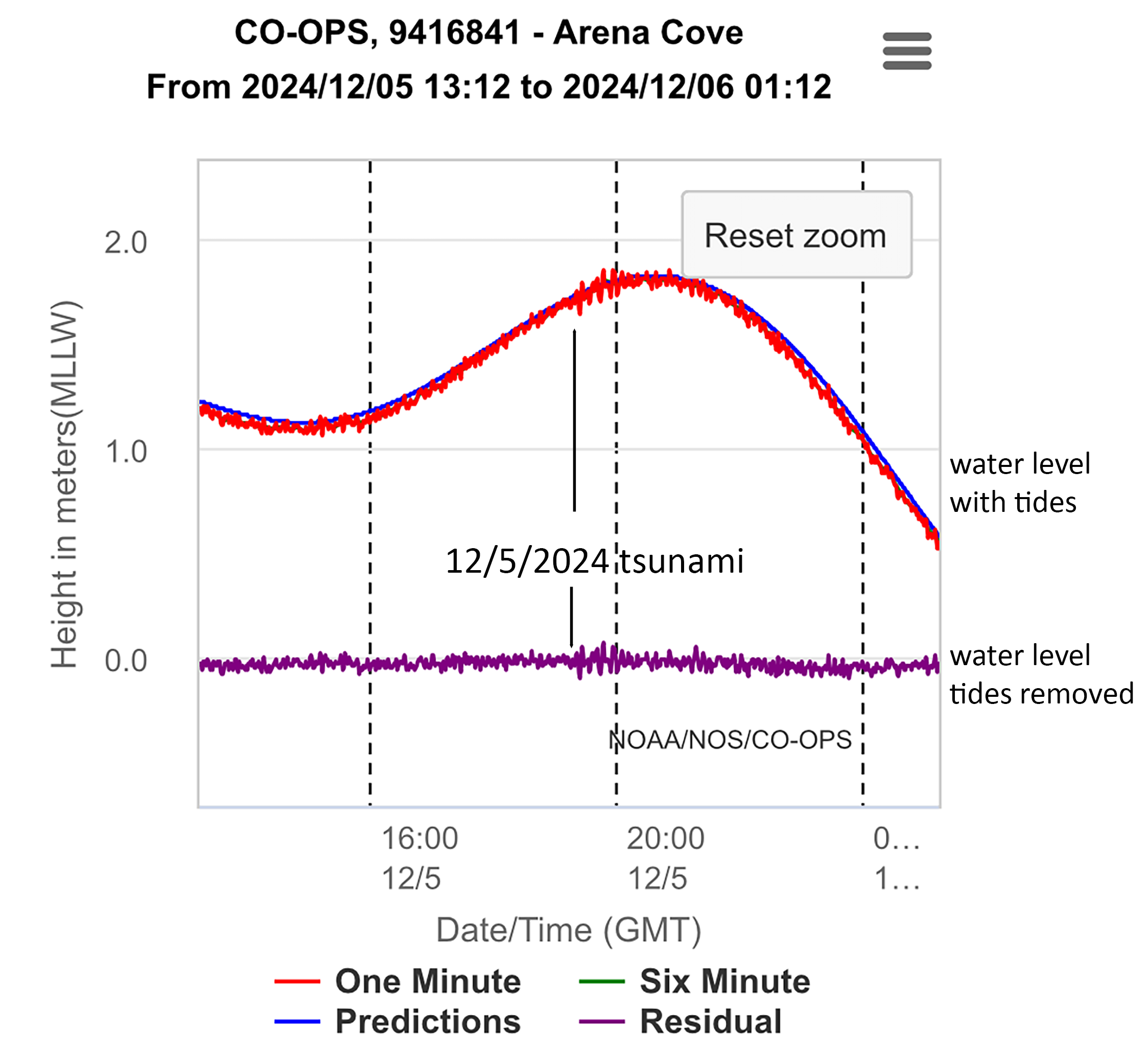
The tsunami warning was canceled 70 minutes after the earthquake when officials at the NTWC confirmed that no significant waves had been generated. A 3.5 inch-high tsunami was recorded on the Arena Cove tide gauge in Mendocino County.
This marigram shows the water level recoved in Arena Cove (near Point Arena, CA). The red line is the measured water level, the blue line is the tidal prediction, and the purple line is the difference between the observed and prediction. The arrival of the tsunami is noted on the graph. Data provided by NOAA Tides & Currents.
Aftershocks of the December 5, 2024 M7 earthquake
As of January 27, 2025, over 540 earthquakes have been reported on our near the rupture zone of the December 5 earthquake.

USGS epicenter map December 5, 2024 to January 27, 2025. Earthquakes are color-coded by age. Events in the past hour are in orange, past day in yellow, past week in white, older than a week in gray.
The majority of the aftershocks occurred in the first week after the earthquake, but the largest to date was a M5.3 on December 14th. The USGS forecasts that aftershocks will likely continue for at least a year and there is still a chance of another aftershock in the M5 range.

Follow the events in Dr. Dengler's Not My Fault articles
- December 7, 2024, Ready for the Big One? Thursday’s quake shows we have a long way to go, Eureka Times-Standard, (Download the file)
- March 2, 2024, Explaining the collapse of coastline south of Centerville Beach, Eureka Times-Standard, (Download the file)
- December 31, 2022, Data explains duration of 6.4 quake, hundreds of aftershocks, Eureka Times-Standard, (Download the file)
- December 24, 2022, Earthquakes are not fun - make sure you are prepared for the next one, Eureka Times-Standard, (Download the file)
- January 29, 2022, The December M6.2 was really two earthquakes, Eureka Times-Standard, (Download the file)
- December 25, 2021, Magnitude 6.2 earthquake in the triple junction, Eureka Times-Standard, (Download the file)
December 20, 2022 2:34 am PST
**Note, this section is still under development**
At 2:34 AM PST, a magnitude 6.4 earthquake occurred offshore in the Gorda plate, 2 miles northwest of False Cape. The earthquake rupture began at a depth of 11 miles beneath the sea floor and ruptured towards and beneath the coast in an ENE direction. About 12 miles of fault participated in the rupture, the maximum slip about 2 feet and entirely within the Gorda plate, beneath the interface between the North American and Gorda plate. Fault slip was left lateral strike-slip, with areas north of the fault moving to the WSW compared to areas south the fault.

Red circle shows the location of the December 20, 2024, epicenter. The rupture propagated in an east-northeast direction for about 12 miles (shown by the longer black line) and the two sides of the fault moved horizontally in the directions shown by the red arrows. The largest aftershock (M5.4) occurred 12 days later on a different fault shown by the shorter black line, the orange arrows show the fault slip. Grey circles are other aftershocks recorded in the first three months following the earthquake.

USGS “Did You Feel It?” reports were clustered in Northern California but there were a few reports as far away as San Diego and Seattle.
The earthquake produced some of the strongest ground motions ever recorded in a California earthquake. The strongest shaking was in Rio Dell.
The National Tsunami Warning Center issued a Tsunami Statement 5 minutes after the earthquake noting was no tsunami threat associated with this earthquake due to its size and location.
Learn more about these events below:
- January 7, 2023, A shaky start to 2023, Eureka Times-Standard, (Download the file)
- January 4, 2023, Number of displaced Humboldt County residents continues to mount after New Year's aftershock, Jefferson Public Radio
- December 31, 2022, Data explains duration of 6.4 quake, hundreds of aftershocks, Eureka Times-Standard, (Download the file)
- December 30, 2022, California's Third Shakiest Earthquake , EcoNews Report
- December 24, 2022, Earthquakes are not fun - make sure you are prepared for the next one, Eureka Times-Standard, (Download the file)
- December 23, 2022, 6.4 Earthquake in Humboldt County, California. Talking with Dr. Lori Dengler, Professor Emeritus, Cal Poly Humboldt, The San Francisco Experience
- December 23, 2022, Lori Dengler joins Headline Humboldt to discuss the Dec 20th M6.4 earthquake , KEET- Headline Humboldt